Steep Scotland
This site uses cookies to help understand how you and other visitors use the site. You can see a list of these cookies, and what they are used for, on the cookie information page.

By visiting any other page on this website, you are consenting to the use of cookies by this site. You will only see this message once, but will be able to set your preference at any time on the cookie information page.

Cairn Toul

Cairn Toul.   Photo: Scott Muir

This magnificent mountain offers fantastic late season skiing on 3 aspects.  If snow conditions allow, there are 2 runs that offer over 600m of descent when following snow filled stream lines, even when the rest of the hillside appears bare.  None of the descent lines are particularly steep, but are in a great position.  One of descents to the Lairig Ghru could be done to finish off the day, having earlier been down something steeper on Sgor an Lochain Uaine or in Garbh Coire Mór.

Approach

The most logical approach is from Deeside, using bikes to Linn of Dee and then walk round to Corrour Bothy.  Some will opt for approaching via Cairngorm and down Taillears Burn, but this involves a re-ascent to get back to the car at the end of the day.

Relevant Weather Forecasts

Met Office Logo
MWIS Logo
Mountain-forecast.com Logo

Relevant Avalanche Forecasts

There are 2 Scottish Avalanche Information Service forecasts worth considering for Cairn Toul.

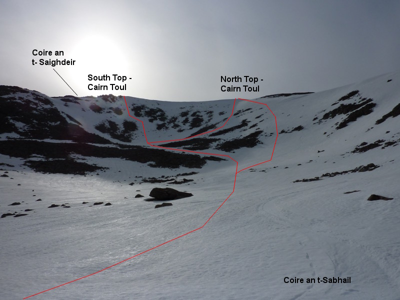
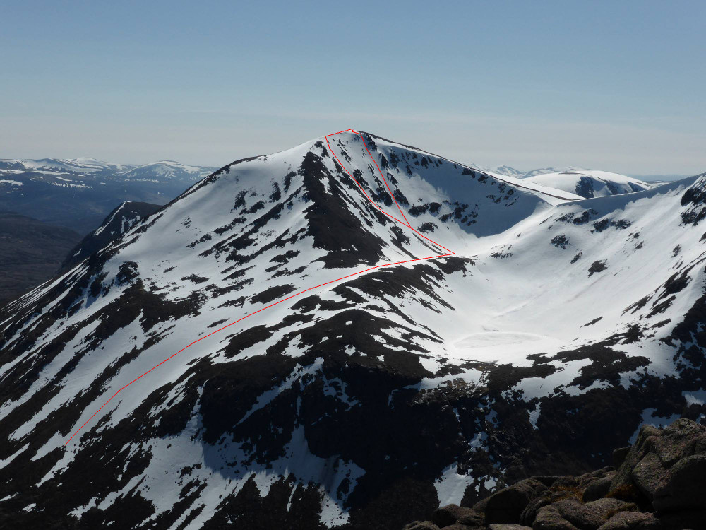
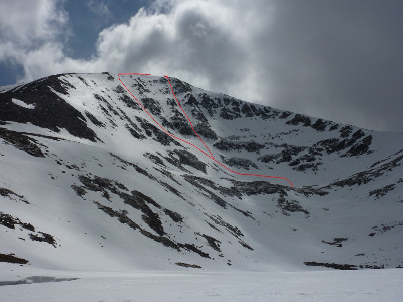
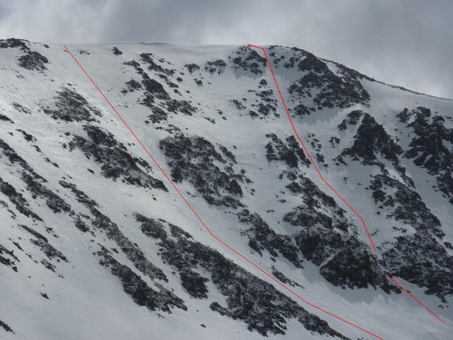
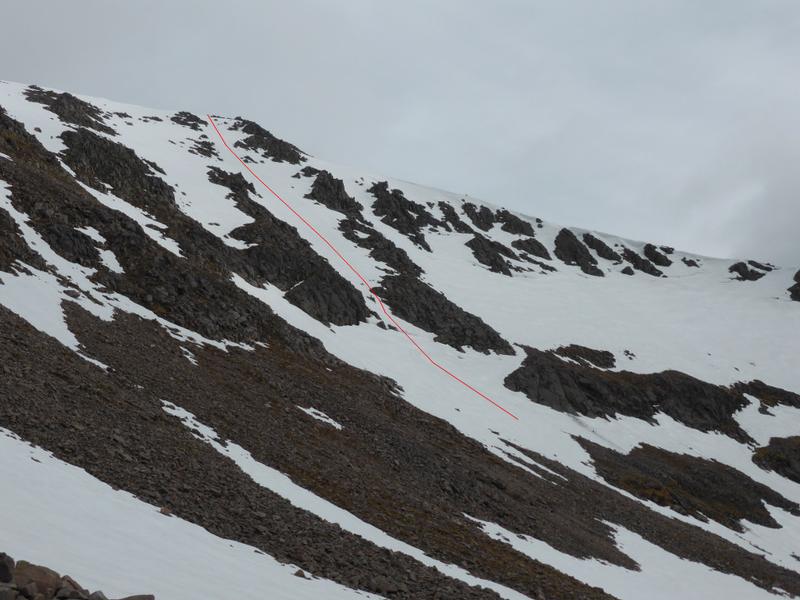
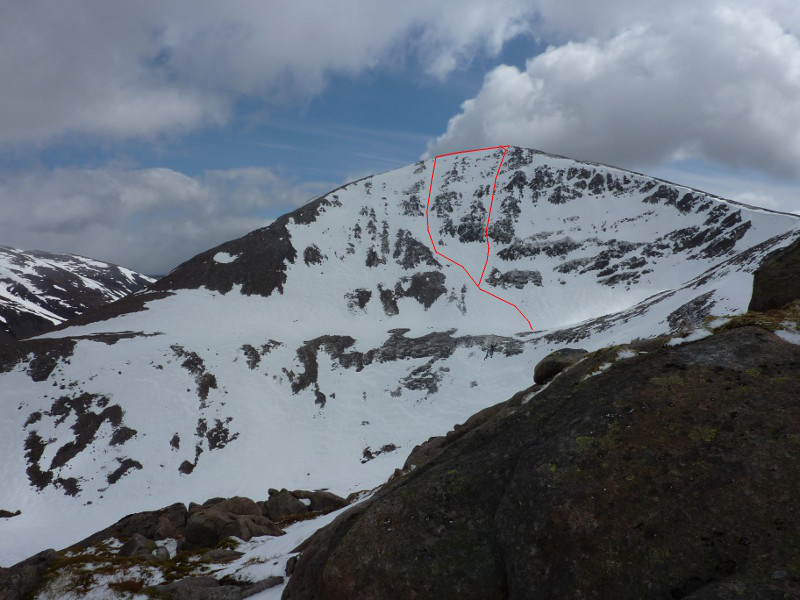
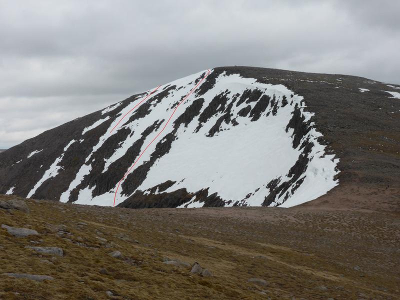
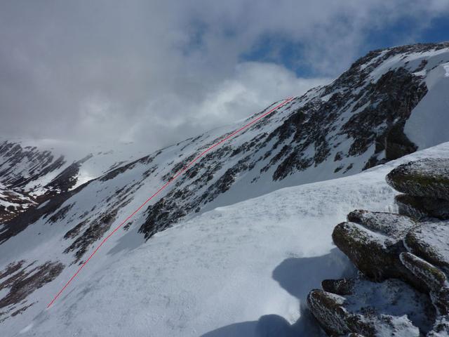
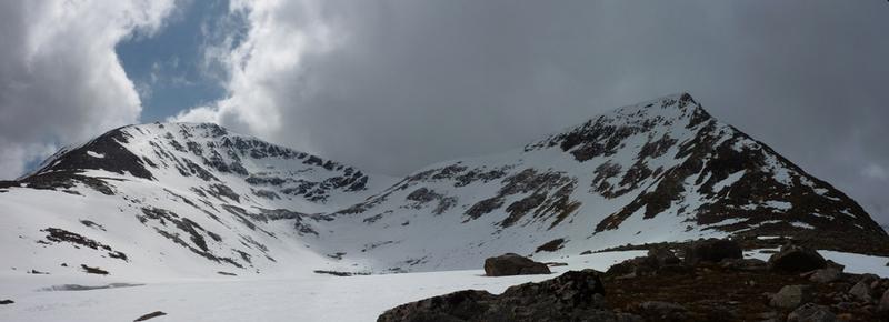
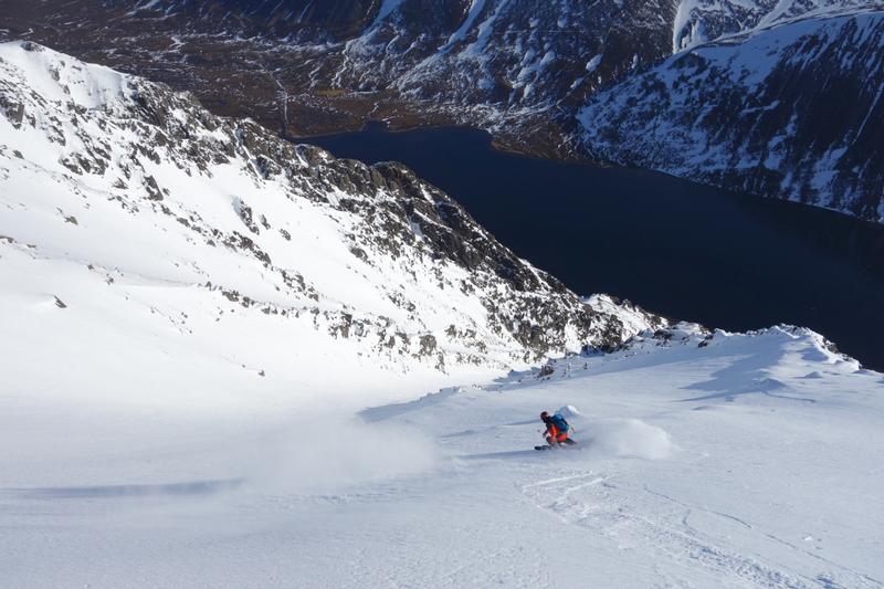
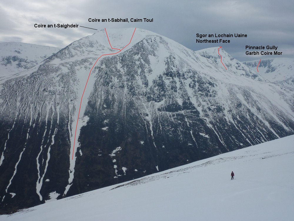
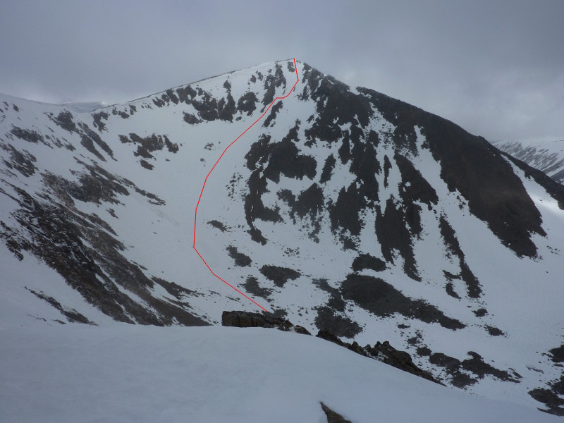
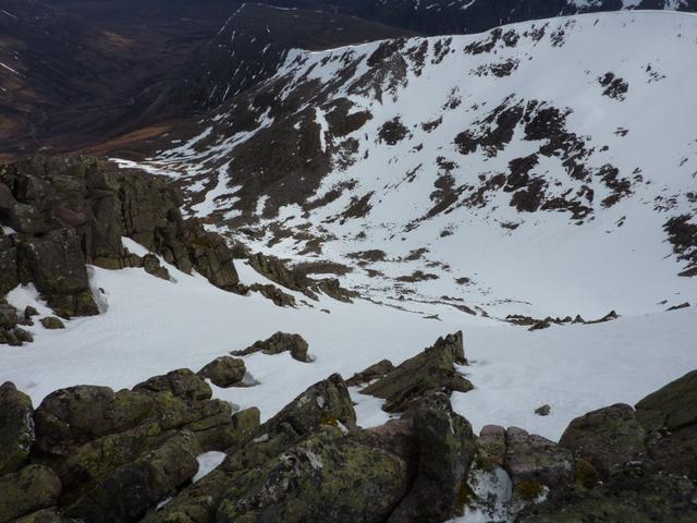
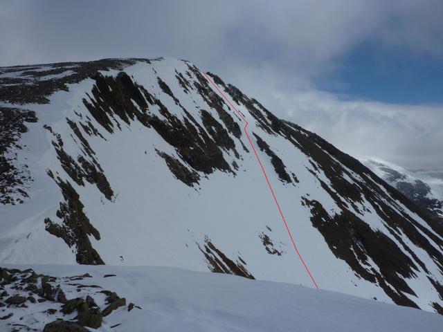
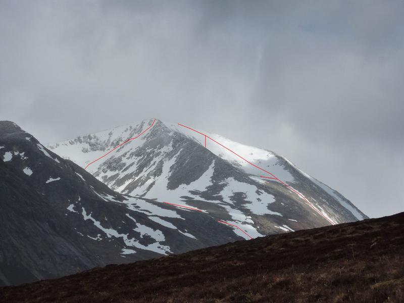
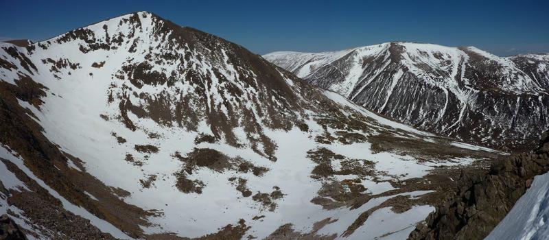
A superb run down the south face, starting by the southern cairn on the summit ridge.  The descent starts down a shallow corridor, before cutting across a small snow arete that allows access to the bowl of the corrie.  If snow cover allows, then a direct line into the corrie would obviously be possible, but the line described persists late into the season, despite its southerly aspect.  The southern main drainage line from the corrie often holds snow late into the season, offering a long descent low down into the Lairig Ghru.  If this is present, then the overall descent can be in excess of 600m!

View from the opposite side of Coire an t-Saighdeir to the south top of Cairn Toul  Photo: Scott Muir
Looking back up the outflow of Coire an t-Saighdeir  Photo: Scott Muir
Looking down into Coire an t-Saighdeir from the south summit of Cairn Toul  Photo: Scott Muir
View of Coire an t-Saighdeir line from the col to the Southwest  Photo: Scott Muir
Approaching Cairn Toul from the South.  Coire and t-Saighdeir is on the left, Coire and t-Sabhail on the right.  Photo: Scott Muir
Late May 2013  Photo: Scott Muir
Grid Reference: NN 96497

Approximate Start Height: 1290m

Approximate Descent: 350m

General Aspect: South

Climbing Grade: n/a

Notes: Comparable to a resort black run in the upper section.
 

While descending the justifiably popular Taillears Burn, you can't help but notice the long tongue of snow descending into the Lairig Ghru from the high, shallow East facing corrie of Cairn Toul.  It looks very steep from the opposite side of the glen, but luckily, it is at a gradient that makes it highly enjoyable to ski.  Arguably, it's is a better run than Taillears...

If you are approaching from the south, and the hillside looks bare, persevere.  The drainage line from the corrie is deep low down, and as such, holds snow well late into the season, sometimes lower than Taillears facing it.

You have a choice of options from the summit ridge of Cairn Toul into Coire an t-Sabhail.  From the southern end of the summit ridge, the steepest line into the corrie can be found.  It can have boulders poking through the snow, so be aware of that.  From the northern end of the summit ridge, the angle is easier, maybe equivalent to a red run, and arguably more in keeping with the rest of run.  At the corrie lip, there is sometimes a break in the snow necessitating a very short walk, but it's worth it.  As the snow steepens, the Lairig Ghru opens out below you, and you should see a strip of snow giving you a several hundred metre descent line.  Be aware of substantial glide cracks, holes in the snow and in particular lower down, weak snow bridges.

Looking back up Coire an t-Sabhail at the lines from the summit ridge.  Photo: Scott Muir
Looking back up the line of the outflow of Coire an t-Sabhail  Photo: Scott Muir
Looking back up the outflow of Coire an t-Saighdeir  Photo: Scott Muir
Looking down the line of the outflow of Coire an t-Sabhail  Photo: Scott Muir
Approaching Cairn Toul from the South.  Coire and t-Saighdeir is on the left, Coire and t-Sabhail on the right.  Photo: Scott Muir
Grid Reference: NN 96397

Approximate Start Height: 1290m

Approximate Descent: 600m

General Aspect: East

Climbing Grade: n/a

Notes: The line beneath the South summit is steeper than the lines beneath the North summit
 

Although not at long as the other lines described on Cairn Toul, this descent takes you into one of the most beautiful corries in the Cairngorms.  The face comprises of a number of shallow runnels, separated from each other by shallow rocky ridges.  Your choice of descent on the day should be dictated by the snow cover.

One of the runnels directly below the summit is the best one, with a relatively consistent gradient all the way down to the shallow ridge above the lochan.  Set off from the cairn at the North end of the Cairn Toul summit ridge.  After a few metres, you should be able to ski left around, and then below some rocks (effectively doing an about turn), bringing you into the runnel.  The way down from there will be obvious.  An alternative, depending upon snow cover, is to ski down the North ridge some way before dropping into a complete runnel.  

It is worth having a look at the face prior to skiing it to ensure you don't cut down the wrong runnel - those nearest the summit often have rocky sections.   You can look across the face from the col between Sgor an Lochain Uaine and Cairn Toul to give you an idea of the snow cover. 

If you want to re-ascend Cairn Toul from the corrie, you can scramble up the scree covered North ridge of Cairn Toul, or find your way up to the col between it and Sgor an Lochain Uaine, where there is usually a break in the cornice. The striking Northeast ridge of Sgor an Lochain Uaine is a very good ascent, although be aware it can be a little tricky at the top. If you don't want to climb back out, you may be able to continue on down into the Lairig Ghru following the often present line of snow that sits in a channel below the face, bounded by a shallow ridge above the lochan.  At the end of this channel, long lasting snowfields descend towards the Lairig Ghru.

Cairn Toul from Braeriach, showing the descents from the summit into Coire an Lochain Uaine  Photo: Scott Muir
 The view from the northern end of Lochan Uaine to the descent lines from the top of Cairn Toul  Photo: Scott Muir
Close up of the Lochan Uaine face.  Photo: Scott Muir
May 2014:  Looking back up the direct line below the summit.  Photo: Scott Muir
The Lochain Uaine face of Cairn Toul from the Northeast ridge of Sgor an Lochain Uaine.   Photo: Scott Muir
The view from the Cairn Toul - Sgor an Lochain Uaine col, May 2014  Photo: Scott Muir
The view of the Lochan Uaine face from above the Sgor an Lochain Uaine - Cairn Toul col.  Photo: Scott Muir
The view from the Northern end of Lochain Uaine 3rd of May 2010, with Cairn Toul on the left, Sgor an Lochain Uaine on the right. There is usually a break in the cornice at the col.  Photo: Scott Muir
Grid Reference: NN964975

Approximate Start Height: 1291m

Approximate Descent: 380m

General Aspect: Northwest

Climbing Grade: n/a

Notes: Only one narrow steeper section - comparable to a black run.
 
Bookmark and Share
Mountain List
 
Latest News
Map updates
Updates to the mapping functionality
16-Oct-21
Overdue site content updates!
New pages and updates to the site, including Gleann Eanaich, Bla Bheinn and Beinn Alligin
07-Apr-21
 
 
Random Image
Site developed by Scott Muir
Site News   |   Disclaimer   |   Accessibility   |   Site Map   |   Cookie Information  
© Steep Scotland 2024