Steep Scotland
This site uses cookies to help understand how you and other visitors use the site. You can see a list of these cookies, and what they are used for, on the cookie information page.

By visiting any other page on this website, you are consenting to the use of cookies by this site. You will only see this message once, but will be able to set your preference at any time on the cookie information page.

Ben Macdui

Ben Macdui.   Photo: Scott Muir

The steeper lines of Coire Sputan Dearg are described separately, and whereas the descents from Ben Macdui to the South and West are maybe not as steep, they are certainly much bigger.  It wouldn't be right not to mention them!

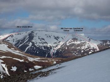
The large dome of Ben Macdui is a popular snow sure tour from Cairngorm and back.   Even in lean snow conditions, it's often possible to descend any of the 3 lines described.  The hanging corrie between the Allt a' Choire Mhòir and Allt Clach nan Taillear also gets skied, with a significantly steeper entry than the other 3 lines described.

Approach:

The ski centre car park on Cairngorm is a popular starting point, and is feasible for descents of Taillears or the Allt a' Choire Mhòir, but less so if you intend to descend the line of Coachan na Cothaiche.  Using a mountain bike and cycling from Linn of Dee to Luibeg makes the Southern approach much more appealing.

Relevant Weather Forecasts

Met Office Logo
MWIS Logo
Mountain-forecast.com Logo

Relevant Avalanche Forecasts

There are 2 Scottish Avalanche Information Service forecasts worth considering for Ben Macdui.

Apart from being a bit of a mouthful trying to pronounce the name, this is a fantastic, fairly snow sure descent despite its southerly aspect.  If you don't fancy trying to pronounce it, you could use the translation, which is "burn of the froth", or even better, the frothy burn. From the top of Ben Macdui, you should be able to get a full 600m of descent, even after a considerable thaw.

The large shallow bowl below the Sputan Dearg-Macdui col is very easy angled, but just watch out for big holes during a thaw!  Head for the outflow of the bowl, staying just right of the stream line.  Even if it is a bit patchy with heather showing through, stay on the right hand side and keep going.  As the angle steepens, you should then be presented with a long tongue of snow forming the West bank of the stream line that reliably offers a descent to the 700m contour. 

The large slope forms the upper section of the run.  Taken from Sron Riach  Photo: Scott Muir
Descending the easy upper bowl in excellent conditions  Photo: Scott Muir
Excellent conditions in the upper bowl  Photo: Scott Muir
Looking back up the line of Caochan na Cothaiche  Photo: Scott Muir
Looking back up the upper bowl.  Photo: Scott Muir
Looking down the lower section of the run after a considerable thaw (February 2008)  Photo: Scott Muir
The lower section of the stream line, taken from above the Luibeg Burn  Photo: Scott Muir
Grid Reference: NN996985

Approximate Start Height: 1220m

Approximate Descent: 520m

General Aspect: South

Climbing Grade: n/a

Notes: n/a
 

Taillears Burn is a popular target for folk with touring kit.  Sitting on top of Ben Macdui, having toured from the ski centre, it must be really tempting for many to descend it.  Those that do face a considerable walk/skin back out, but it's worth it.  If you have approached from the South, you face a long trek round the good path below Can a' Mhaim, but again, it's worth it.

The now out of print 1987 SMC guide to "Ski Mountaineering in Scotland" describes the descent as "one of the finest and most challenging ski-runs in the Scottish mountains".  In the context of the other lines described on this site, the "most challenging" aspect of that statement may not hold true, but it is a fine descent!

The descent can be split into 3 distinct sections: the upper bowl contains the steepest section before opening out onto a wide easy angled area, followed by a narrow cornice lined stream line descent.  After a thaw, or late season, the lower section can appear broken.  The snow will be more obvious on the right hand side of the stream, and a deviation into the bed of the stream itself may be required (assuming there's snow in it!).  It's often beneficial to return to the right bank soon, as another strip of snow often persists on the right bank quite low down.

Enjoying the view south down the Lairig Ghru on a late season descent.  Photo: Scott Muir
Keep going...  Photo: Scott Muir
The lower section often keeps snow on the north side of the stream line.  Photo: Scott Muir
The reason you should keep going - there's often more!  Photo: Scott Muir
The upper bowl of Taillears  Photo: Scott Muir
Grid Reference: NN994985

Approximate Start Height: 1220m

Approximate Descent: 600m

General Aspect: Southwest

Climbing Grade: n/a

Notes: n/a
 

A fine big descent into the Lairig Ghru that can be started from the summit of Ben Macdui.  The easy angled turns into Coire Mòr allow the legs to warm up before dropping into the main line.  The bank on skiers left often holds the most snow.   

Descending the right hand bank in lean times  Photo: Scott Muir
Enjoying superb spring snow in the upper bowl, late March 2022  Photo: Scott Muir
Looking across at the line from Braeriach in April 2014.  There are skiers on it.  Photo: Scott Muir
Looking back up, having descended the skiers right bank, March 2016  Photo: Scott Muir
Lots of room in April 2014, taken from Braeriach  Photo: Scott Muir
Nearing the change in gradient, late March 2022  Photo: Scott Muir
Nearing the change in gradient, March 2016  Photo: Scott Muir
On the skiers left bank, late March 2022  Photo: Scott Muir
Superb views, March 2016  Photo: Scott Muir
Grid Reference: NN989993

Approximate Start Height: 1309m

Approximate Descent: 450m

General Aspect: West

Climbing Grade: n/a

Notes: n/a
 

Skiing & Snowboarding in the Cairngorms National Park

COMING SOON! A complete guide to skiiing and snowboarding in Scotland's Cairngorms National Park.

This book contains everything you need for planning your next adventure in the Scottish Highlands including route descriptions, route gradings with slope aspects, maps, pictures with topography, and pictures of the mountains in a variety of snow conditions. All of this is weaved together beautifully alongside the history, folklore and stories behind the names of the mountains and coires we travel through.

A collaboration by Blair Aitken, Jamie Johnston, Katie Henderson and Scott Muir, with additional contributions from other regular Cairngorm adventurers. The guide suits both ski tourer and splitboarder and includes everything from mellow, low angled slopes, all the way through to some of the steepest gully skiing in the country.

More details here on the British Backcountry Guidebook page

Mountain List
 
Latest News
Map updates
Updates to the mapping functionality
16-Oct-21
Overdue site content updates!
New pages and updates to the site, including Gleann Eanaich, Bla Bheinn and Beinn Alligin
07-Apr-21
 
 
Random Image
Site developed by Scott Muir
Site News   |   Disclaimer   |   Accessibility   |   Site Map   |   Cookie Information  
© Steep Scotland 2024