Steep Scotland
This site uses cookies to help understand how you and other visitors use the site. You can see a list of these cookies, and what they are used for, on the cookie information page.

By visiting any other page on this website, you are consenting to the use of cookies by this site. You will only see this message once, but will be able to set your preference at any time on the cookie information page.

Coire Etchachan

Coire Etchachan.   Photo: Scott Muir

The relatively low lying and remote Coire Etchachan may not spring to mind when thinking of ski locations in the Cairngorms.  However, it is home to a wee gem in the form of Forked Gully, and is definitely worth a visit.

Approach

The most logical approach is from the Linn of Dee car park.  It is a long approach, and a mountain bike is extremely useful.  Once at Derry Lodge, there is a choice:  cross the bridge, and follow the path through the woods, or take the path on the East side of the Derry Burn.  If walking, cross the bridge, as it is shorter.  Both have drainage ditches, but on balance, the path on the East side of the Derry Burn is probably easier to cycle. Once beyond the bridge where the two paths meet, the cycling eases again.  It's not worth taking the bikes beyond the stream crossing at NO036975.

An alternative from Derry Lodge is to dump the bike there, and tour over Derry Cairngorm before locating the top of Forked Gully for a descent into Coire Etchachan.  It's a long walk out, but would provide a logical circular route.

Hutchison Memorial Hut

The Hutchison Memorial Hut provides a welcome break, and possibly somewhere to leave excess kit (e.g. walking boots) if in for a day trip.    The bothy was refurbished during the summer of 2012, and is a small, but comfortable place to spend a night.  It is now has a woodburner, so bring your own fuel if you plan to use it.  Despite clear (and witty) signs asking you to consider the environment around the bothy, people seem to still have difficulty in understanding the right thing to do when it comes to defecating.  The bothy is quite remote, and people are understandably tired having made the long journey to get there, but could you please make a little bit of an effort to find a spot further than the doorway if you need to go...

Other options

The almost 400m high, South facing Stob Coire Etchachan has a number of shallow gully lines, all about Grade I.  One was skied by the author in 2014, and a return trip is planned for favourable conditions in the coming season(s)!

Relevant Weather Forecasts

Met Office Logo
MWIS Logo
Mountain-forecast.com Logo

Relevant Avalanche Forecasts

There is one relevant Scottish Avalanche Information Service forecast for Coire Etchachan.

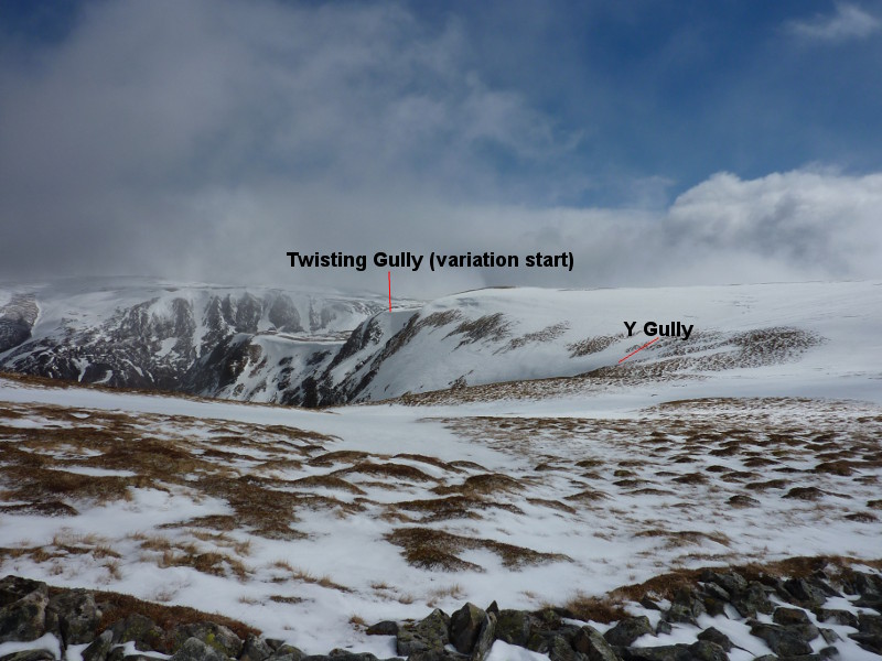
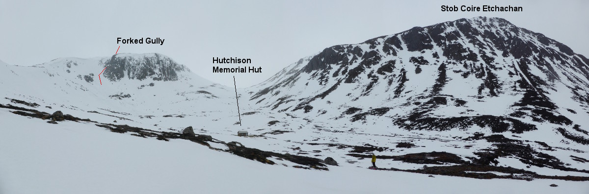
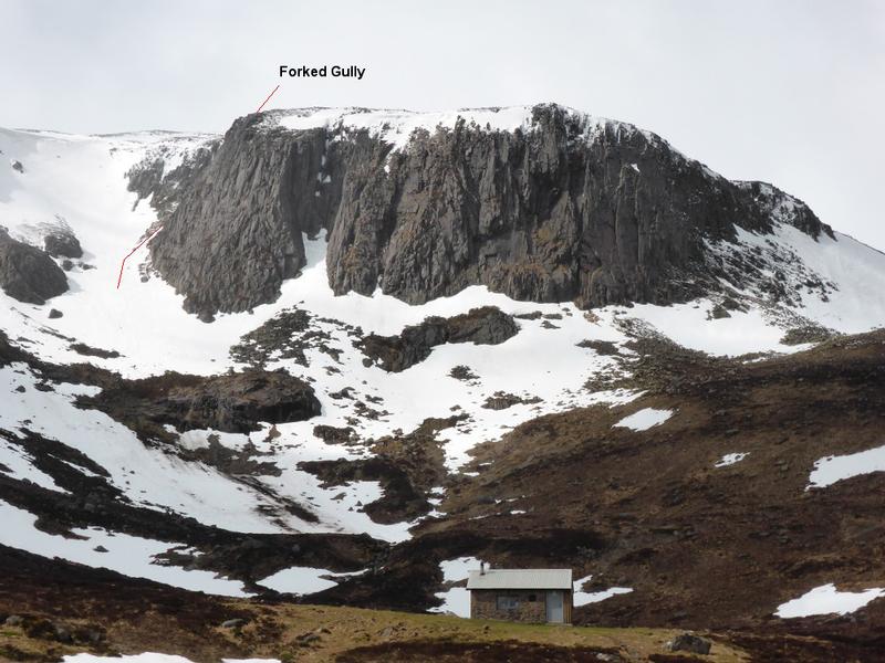
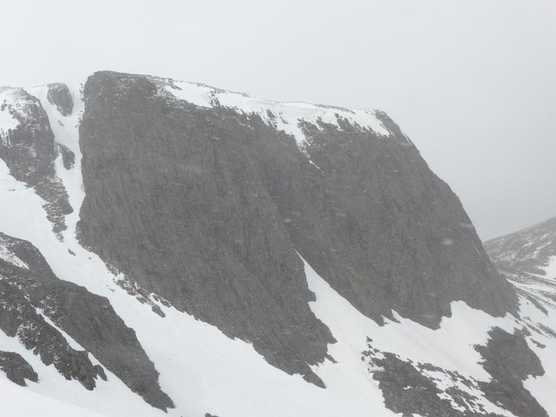
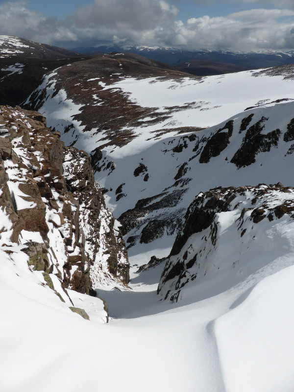
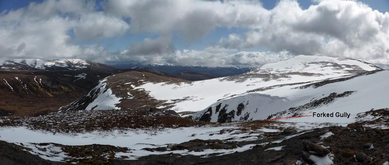
Despite being short, and at the end of a long approach, Forked Gully is a wee gem.  It is located at the southern end of Creagan a' Choire Etchachan, the fine cliff that dominates the view as you enter Coire Etchachan from the East.   The gully is hidden from view from the corrie floor, but you will get a view into it if you ascend steep slopes on the south side of the corrie.

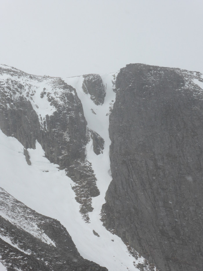
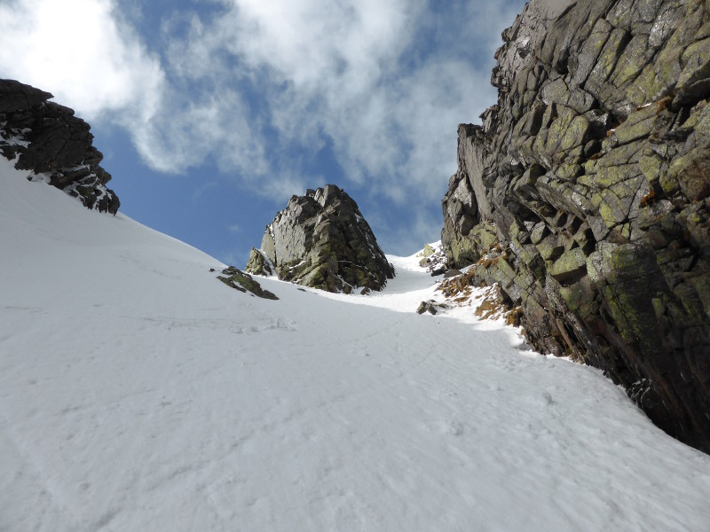
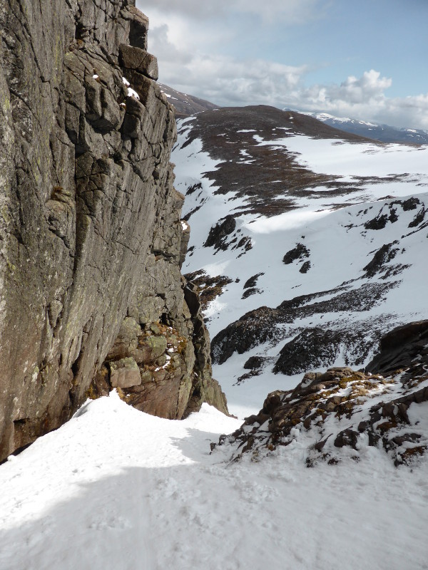
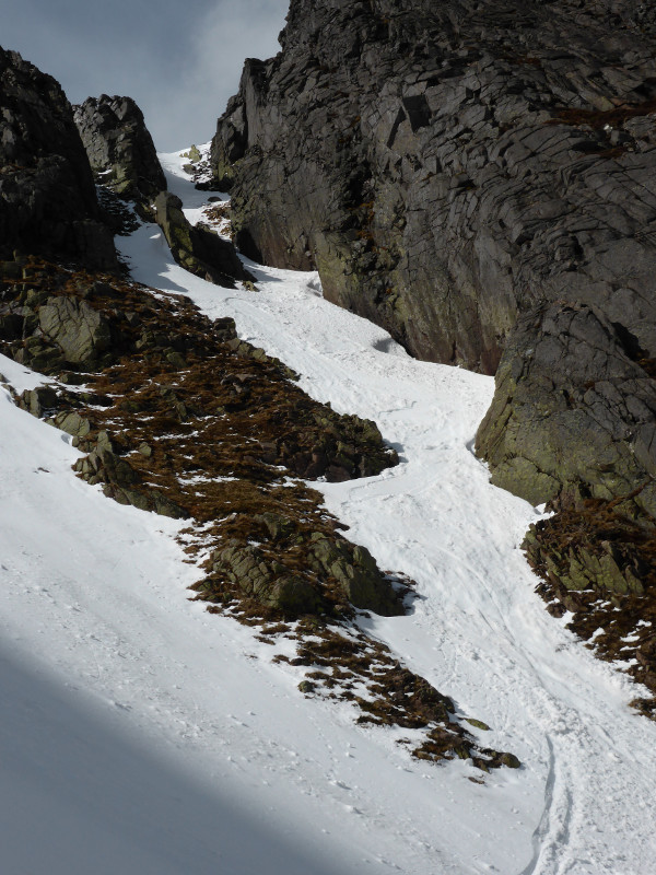
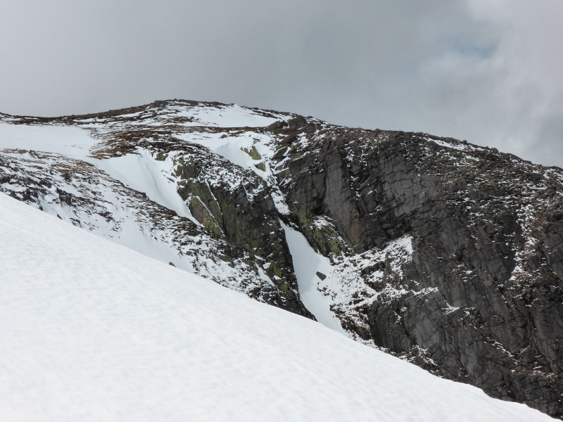
As the name suggests, the gully is indeed "forked".  A small rock island separates the two short gullies at the top of the main gully.  The skiers left fork is the most aesthetic line, with a steep, almost overhung granite wall bounding the left hand side of the gully.  Although the gully is not even 100m high, you should be able to get a good descent to the corrie floor (about 300m vertical), as this side of the corrie holds the most snow usually.

The gully is marked as a notch in the cliffs on the OS 1:50000 maps.

Looking directly into Forked Gully from the slopes to the East.  Photo: Scott Muir
Creagan a' Choire Etchachan, the Hutchison Memorial Hut, and the location of Forked Gully  Photo: Scott Muir
Forked Gully from the East  Photo: Scott Muir
Looking back up to the fork.  Photo: Scott Muir
Looking down the gully from below the fork.  Photo: Scott Muir
Looking down the skiers left fork.  Photo: Scott Muir
Skiers left fork.  Photo: Scott Muir
The exit of the gully.  Photo: Scott Muir
The location of the top of the gully from the Northeast  Photo: Scott Muir
The top of the forks from the South.  Photo: Scott Muir
Grid Reference: NO015997

Approximate Start Height: 1000m

Approximate Descent: 300m

General Aspect: East

Climbing Grade: I

Notes: Narrow, but never particularly steep.
 
Bookmark and Share
Mountain List
 
Latest News
Map updates
Updates to the mapping functionality
16-Oct-21
Overdue site content updates!
New pages and updates to the site, including Gleann Eanaich, Bla Bheinn and Beinn Alligin
07-Apr-21
 
 
Random Image
Site developed by Scott Muir
Site News   |   Disclaimer   |   Accessibility   |   Site Map   |   Cookie Information  
© Steep Scotland 2024